Upgrade to Pro

  • GUBBIO@ITALYMERRYXMAS&HAPPY NEWYEAR
    The LARGEST CHRISTMAS tree in the WORLD is located, which is lit every December 7. This record, registered in the GUINNESS BOOK was set in 1981 on MOUNT INGINO which rises above the city. The tree boasts about 700 light elements of different shapes and colors, reaching a height of more than 750 meters and covering a surface area of 130,000 square meters. Its unique structure extends to the medieval walls of the city, and its star at the mountaintop reaches the height of the Basilica of Sant'Ubaldo, making it an impressive symbol of Christmas in the region.

    Credits Conocimientum
    #didyouknow #didyouknowfacts #DidYouKnow
    🇮🇹🎊🇮🇹GUBBIO@ITALY🇮🇹🎊🇮🇹MERRYXMAS&HAPPY NEWYEAR🎄🎄 🎄🎄 🎄🎄 🎄🎄 The LARGEST CHRISTMAS tree in the WORLD is located, which is lit every December 7. This record, registered in the GUINNESS BOOK was set in 1981 on MOUNT INGINO which rises above the city. The tree boasts about 700 light elements of different shapes and colors, reaching a height of more than 750 meters and covering a surface area of 130,000 square meters. Its unique structure extends to the medieval walls of the city, and its star at the mountaintop reaches the height of the Basilica of Sant'Ubaldo, making it an impressive symbol of Christmas in the region. Credits Conocimientum #didyouknow #didyouknowfacts #DidYouKnow
    Love
    1
    ·42 Views ·0 Reviews

  • AUSTRIA
    This is stunning pillar road, an engineering marvel that seems to float over the mountainous landscape. This elevated path not only overcomes challenging terrain but also offers a unique visual experience, surrounded by lush forests and deep valleys. Designed to ensure safety and efficiency, it is a perfect example of how technology can integrate harmoniously with nature, creating a connection between functionality and beauty.
    Credits: Flash curiosidades
    #didyouknow #didyouknowfacts #DidYouKnow
    🇦🇹🛣️😍🇦🇹AUSTRIA🇦🇹🛣️😍🇦🇹 This is stunning pillar road, an engineering marvel that seems to float over the mountainous landscape. This elevated path not only overcomes challenging terrain but also offers a unique visual experience, surrounded by lush forests and deep valleys. Designed to ensure safety and efficiency, it is a perfect example of how technology can integrate harmoniously with nature, creating a connection between functionality and beauty. Credits: Flash curiosidades #didyouknow #didyouknowfacts #DidYouKnow
    Wow
    1
    ·50 Views ·0 Reviews
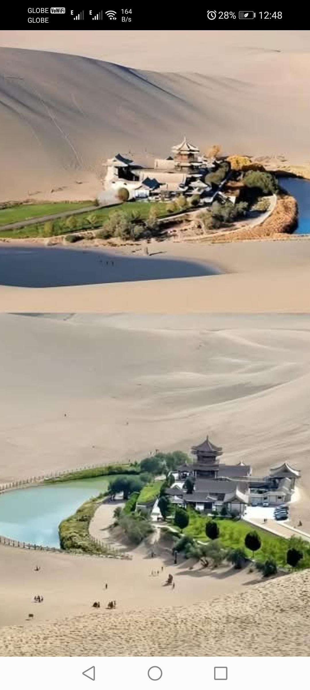
  • Moon Lake
    Located in GOBI DESSERT
    @


    Is a natural CRESCENT - SHAPED formation surrounded by sand dunes. Also known as Yueyaquan, this oasis has been a key point for travelers on the Silk Road for centuries. Despite being in an arid environment, it is maintained thanks to a combination of groundwater and modern conservation efforts. Its unique beauty and historical significance make it a standout tourist destination.
    Credits: Curiosidades
    #didyouknow #didyouknowfacts #DidYouKnow
    A curious fact about Moon Lake is that, despite being surrounded by the arid Gobi Desert, its crescent shape has remained virtually intact for over 2,000 years. This is due to both its groundwater and recent human interventions that have helped preserve it from desertification. #curiosities
    🎆🎇🎆Moon Lake🎇🎆🎇 Located in GOBI DESSERT @ 🇨🇳🇨🇳🇨🇳🇨🇳🇨🇳🇨🇳🇨🇳🇨🇳🇨🇳🇨🇳🇨🇳🇨🇳 👇👇👇👇👇 👇👇👇👇👇 Is a natural CRESCENT - SHAPED formation surrounded by sand dunes. Also known as Yueyaquan, this oasis has been a key point for travelers on the Silk Road for centuries. Despite being in an arid environment, it is maintained thanks to a combination of groundwater and modern conservation efforts. Its unique beauty and historical significance make it a standout tourist destination. Credits: Curiosidades #didyouknow #didyouknowfacts #DidYouKnow A curious fact about Moon Lake is that, despite being surrounded by the arid Gobi Desert, its crescent shape has remained virtually intact for over 2,000 years. This is due to both its groundwater and recent human interventions that have helped preserve it from desertification. #curiosities
    Wow
    1
    ·100 Views ·0 Reviews
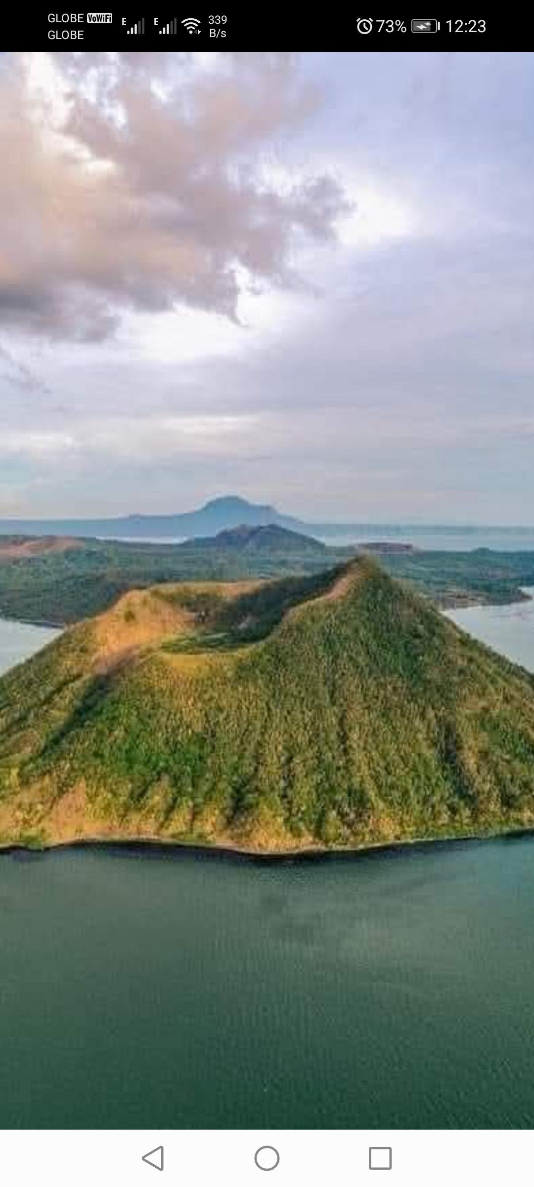
  • Taal Lake is a SALT WATER
    Located @ BATANGAS

    Alam Mona ba to?
    Maka wow ka talaga
    Taal Lake was Salt Water prior to 1754.
    The huge 1754 eruption that lasted for 6 months from May to December 1754 changed the salinity of the water from salt to freshwater.

    The Pansipit River narrowed down where once upon a time Galleons can enter from Balayan Bay to Taal Lake.
    It gave way and formed a new land blocking the mouth of the Pansipit River and that land later on became Lemery,Batangas in 1861.
    New islands sprouted up from underneath like Napayong Island located in Tanauan
    This gave way to new forms of species like the Maliputo and Tawilis.
    Maliputo was actually a Trevally or Talakitok but since it turned freshwater, then it became the Maliputo
    Tawilis was actually a sardine that turned into a freswater sardine trapped inside the lake when the salinty changed.
    There are fossils of old coral reefs in Taal Lake proving that once upon a time it was saltwater. The last SHARK sighting in Taal was in 1935.

    ----------------------------------------------

    -Additional facts-

    1. Lake within a caldera (Taal Volcano)
    2. Volcano within a lake (Taal Volcano Island)
    3. Lake within a volcano within a lake!

    This rare formation is due to:

    1. Volcanic activity creating the caldera
    2. Erosion and sedimentation forming the lake
    3. Ongoing volcanic activity shaping the island

    Taal Lake's characteristics:

    1. Located in Batangas, Philippines
    2. Approximately 25 km x 30 km (15.5 mi x 18.6 mi)
    3. Maximum depth: 172 meters (564 ft)
    4. Contains Vulcan Point, the world's smallest active volcano

    Taal Lake's unique features make it:

    1. A popular tourist destination
    2. An important ecological and geological site
    3. A source of freshwater and fisheries

    #highlightsシ#everyone #trendingpost #followers #cctophotonotmine #philipineshistory #followersシ#PHCEHistory #followerseveryonehighlightseveryone #fypシ゚viralシfypシ゚
    😲Taal Lake is a SALT WATER😲 Located @ BATANGAS Alam Mona ba to? Maka wow ka talaga😲 Taal Lake was Salt Water prior to 1754. The huge 1754 eruption that lasted for 6 months from May to December 1754 changed the salinity of the water from salt to freshwater. The Pansipit River narrowed down where once upon a time Galleons can enter from Balayan Bay to Taal Lake. It gave way and formed a new land blocking the mouth of the Pansipit River and that land later on became Lemery,Batangas in 1861. New islands sprouted up from underneath like Napayong Island located in Tanauan This gave way to new forms of species like the Maliputo and Tawilis. Maliputo was actually a Trevally or Talakitok but since it turned freshwater, then it became the Maliputo Tawilis was actually a sardine that turned into a freswater sardine trapped inside the lake when the salinty changed. There are fossils of old coral reefs in Taal Lake proving that once upon a time it was saltwater. The last SHARK sighting in Taal was in 1935. ---------------------------------------------- -Additional facts- 1. Lake within a caldera (Taal Volcano) 2. Volcano within a lake (Taal Volcano Island) 3. Lake within a volcano within a lake! This rare formation is due to: 1. Volcanic activity creating the caldera 2. Erosion and sedimentation forming the lake 3. Ongoing volcanic activity shaping the island Taal Lake's characteristics: 1. Located in Batangas, Philippines 2. Approximately 25 km x 30 km (15.5 mi x 18.6 mi) 3. Maximum depth: 172 meters (564 ft) 4. Contains Vulcan Point, the world's smallest active volcano Taal Lake's unique features make it: 1. A popular tourist destination 2. An important ecological and geological site 3. A source of freshwater and fisheries #highlightsシ゚ #everyone #trendingpost #followers #cctophotonotmine #philipineshistory #followersシ゚ #PHCEHistory #followerseveryonehighlightseveryone #fypシ゚viralシfypシ゚
    Wow
    1
    ·137 Views ·0 Reviews
  • ####TSINGY STONE FOREST @ MADAGASCAR ####
    The Tsingy Stone Forest, in Madagascar, is a spectacular landscape formed by karst formations of limestone that create an intricate labyrinth of pointy needles.
    This unique setting, located mainly in the Tsingy Integrated Nature Reserve in Bemaraha, is a UNESCO World Heritage Site.
    In addition to its impressive geology, it houses exceptional biodiversity, including many endemic species of plants and animals adapted to its challenging conditions.
    It's a fascinating destination for explorers and scientists alike interested in their geology and ecology.
    A fun fact about the Tsingy Stone Forest is that its name, Tsingy, comes from a Malagasy word meaning “where one cannot walk barefoot.” This refers to the sharp formations of limestone making even crossing it with footwear quite a challenge. It's a true natural maze.
    .
    .
    .
    .
    .
    ~Curiosidades~Did you know that~
    #stone #forest #Madagascar #UNESCO #nature #naturelovers #naturephotography #natureza #naturaleza #natural #naturebeauty
    #tourist #tourism #tourpackages #tour #touristattraction #tours
    #fbpost2024 #fbpost #fbpostviral #post #virals #postoftheday #touring #PostViral #viralpost #viralpost2024 #viralpostfb #follower #touristspot #travel #everyonehighlights #everyone #everyonefollowers #everyoneactive #highlights #travelblogger #travelling #travelgram #TravelGoals #everyoneactivefollowers #everyonehighlightsfollowers #highlightseveryonefollowers2024 #highlightseveryone #hihglights #followerseveryonehighlights #followerseveryone #followers #followme #facebookviral #naturevibes #facebookpost #FacebookPage
    #HeritageSite #TravelGoals #NatureLovers #AdventureAwaits #HistoricalLandmark #ExploreMore #CulturalHeritage #Wanderlust #Photography #InstaTravel #BucketList #TravelDiaries
    #curiosities #didyouknow #didyouknowfacts #DidYouKnow
    ####TSINGY STONE FOREST @ MADAGASCAR #### The Tsingy Stone Forest, in Madagascar, is a spectacular landscape formed by karst formations of limestone that create an intricate labyrinth of pointy needles. This unique setting, located mainly in the Tsingy Integrated Nature Reserve in Bemaraha, is a UNESCO World Heritage Site. In addition to its impressive geology, it houses exceptional biodiversity, including many endemic species of plants and animals adapted to its challenging conditions. It's a fascinating destination for explorers and scientists alike interested in their geology and ecology. A fun fact about the Tsingy Stone Forest is that its name, Tsingy, comes from a Malagasy word meaning “where one cannot walk barefoot.” This refers to the sharp formations of limestone making even crossing it with footwear quite a challenge. It's a true natural maze. . . . . . ~Curiosidades~Did you know that~ #stone #forest #Madagascar #UNESCO #nature #naturelovers #naturephotography #natureza #naturaleza #natural #naturebeauty #tourist #tourism #tourpackages #tour #touristattraction #tours #fbpost2024 #fbpost #fbpostviral #post #virals #postoftheday #touring #PostViral #viralpost #viralpost2024 #viralpostfb #follower #touristspot #travel #everyonehighlights #everyone #everyonefollowers #everyoneactive #highlights #travelblogger #travelling #travelgram #TravelGoals #everyoneactivefollowers #everyonehighlightsfollowers #highlightseveryonefollowers2024 #highlightseveryone #hihglights #followerseveryonehighlights #followerseveryone #followers #followme #facebookviral #naturevibes #facebookpost #FacebookPage #HeritageSite #TravelGoals #NatureLovers #AdventureAwaits #HistoricalLandmark #ExploreMore #CulturalHeritage #Wanderlust #Photography #InstaTravel #BucketList #TravelDiaries #curiosities #didyouknow #didyouknowfacts #DidYouKnow
    Wow
    1
    ·323 Views ·0 Reviews
  • The SEAWISE GIANT , the largest ship ever built, measured 457 meters in length and had a cargo capacity of up to 4.5 million barrels of oil, representing 5% of the world's daily crude consumption. It operated from 1979 to 2010, but its size prevented it from passing through the Suez and Panama Canals, restricting its navigation to the Indian Ocean, the Persian Gulf, and the South China Sea.
    Credits: Conocimientum
    #didyouknow #didyouknowfacts #DidYouKnow
    🌊🚢😱 The SEAWISE GIANT , the largest ship ever built, measured 457 meters in length and had a cargo capacity of up to 4.5 million barrels of oil, representing 5% of the world's daily crude consumption. It operated from 1979 to 2010, but its size prevented it from passing through the Suez and Panama Canals, restricting its navigation to the Indian Ocean, the Persian Gulf, and the South China Sea. Credits: Conocimientum #didyouknow #didyouknowfacts #DidYouKnow
    Love
    1
    ·114 Views ·0 Reviews
  • @ $IERRA MADRE
    Facts about: THE Sierra Madre
    The Sierra Madre is the longest mountain range in the Philippines. Spanning over 540 kilometers (340mi) it runs from the province of Cagayan down to the province of Quezon, forming north - south direction on the eastern portion of Luzon, the largest island of the archipelago. It is bordered by the Pacific Ocean to the east, Cagayan Valley to the northwest, Central Luzon to the midwest and Calabarzon to the southwest. Some communities east of the mountain range,along the coast, are less developed and so remote that they could only be accessed by taking plane or boat.
    Source: Wikipedia
    #ditosanuevaecija #TatakNovoEcijano #ProvinceOfNuevaEcija #NuevaEcija #NovoEcijano #shield #typhoonshield #PepitoPH #typhoon
    @ $IERRA MADRE Facts about: THE Sierra Madre The Sierra Madre is the longest mountain range in the Philippines. Spanning over 540 kilometers (340mi) it runs from the province of Cagayan down to the province of Quezon, forming north - south direction on the eastern portion of Luzon, the largest island of the archipelago. It is bordered by the Pacific Ocean to the east, Cagayan Valley to the northwest, Central Luzon to the midwest and Calabarzon to the southwest. Some communities east of the mountain range,along the coast, are less developed and so remote that they could only be accessed by taking plane or boat. Source: Wikipedia #ditosanuevaecija #TatakNovoEcijano #ProvinceOfNuevaEcija #NuevaEcija #NovoEcijano #shield #typhoonshield #PepitoPH #typhoon
    Wow
    1
    ·108 Views ·0 Reviews
  • "Shocking Breaking News! Groundbreaking Archaeological Discovery: Early Giant Skeleton Reveals Evidence of Bipedalism and Never-Before-Seen Posture"
    See more: https://thang2.amazingfornu.com/thang-shocking-breaking-news-groundbreaking-archaeological-discovery-early-giant-skeleton-reveals-evidence-of-bipedalism-and-never-before-seen-posture
    .#Archaeology #AncientHistory #HistoricalSites #Artifacts #CulturalHeritage #ArchaeologicalDig #Excavation #ArchaeologicalFinds #AncientCivilizations #ArchaeologyLovers #DiscoverHistory #Prehistoric #ArchaeologicalDiscoveries #Unearthed #HistoryUncovered #AncientArtifacts #HistoryBuff #LostCivilizations #DiggingHistory #archaeologylife
    "Shocking Breaking News! Groundbreaking Archaeological Discovery: Early Giant Skeleton Reveals Evidence of Bipedalism and Never-Before-Seen Posture" See more: https://thang2.amazingfornu.com/thang-shocking-breaking-news-groundbreaking-archaeological-discovery-early-giant-skeleton-reveals-evidence-of-bipedalism-and-never-before-seen-posture .#Archaeology #AncientHistory #HistoricalSites #Artifacts #CulturalHeritage #ArchaeologicalDig #Excavation #ArchaeologicalFinds #AncientCivilizations #ArchaeologyLovers #DiscoverHistory #Prehistoric #ArchaeologicalDiscoveries #Unearthed #HistoryUncovered #AncientArtifacts #HistoryBuff #LostCivilizations #DiggingHistory #archaeologylife
    Like
    2
    ·165 Views ·0 Reviews
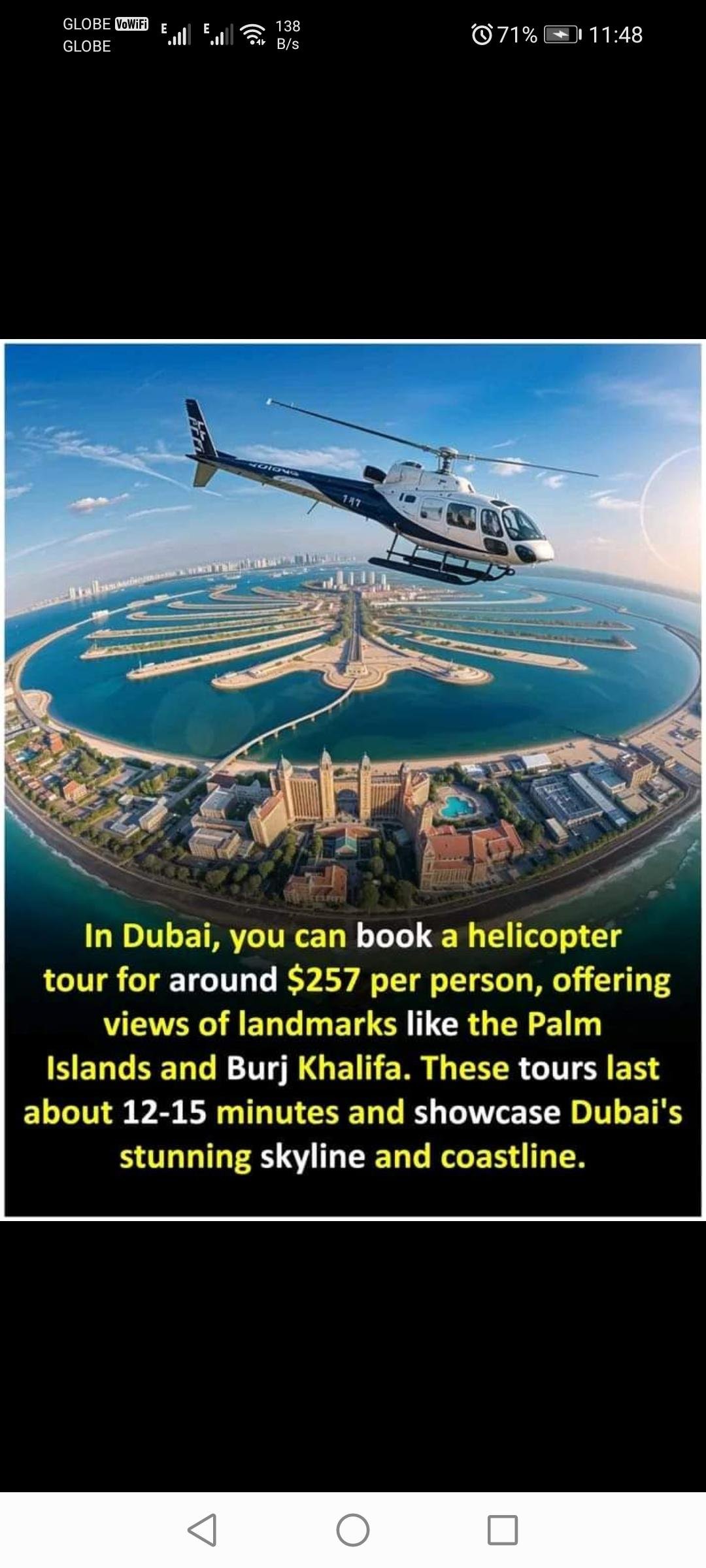
  • Dubai’s helicopter tours provide an unforgettable aerial experience, allowing you to see iconic landmarks like the Palm Jumeirah, the world’s tallest building—Burj Khalifa—and the Burj Al Arab from above. The tours generally last 12 to 15 minutes, giving a quick yet thrilling perspective on the city’s architecture and coastlines. For around $257 per person, it’s a popular choice for those looking to capture Dubai’s scenic and modern skyline in a unique way, offering photo opportunities and memorable views of this vibrant city.
    #facts #DidYouKnow
    Dubai’s helicopter tours provide an unforgettable aerial experience, allowing you to see iconic landmarks like the Palm Jumeirah, the world’s tallest building—Burj Khalifa—and the Burj Al Arab from above. The tours generally last 12 to 15 minutes, giving a quick yet thrilling perspective on the city’s architecture and coastlines. For around $257 per person, it’s a popular choice for those looking to capture Dubai’s scenic and modern skyline in a unique way, offering photo opportunities and memorable views of this vibrant city. #facts #DidYouKnow
    Like
    1
    ·108 Views ·0 Reviews